A Complete Guide to Perfecting Cycling Routes in Japan
Table Of Contents

We have all been there before, we planned what looks to be the ideal route with epic views, endless shorelines, perfect climbs, and not a car in sight. That’s always the goal, but the reality is often quite far from it.
I have seen countless bikepacking videos and blogs where they spent the entire time using Google Maps directions to get from A to B, or worst, just using the most direct road between towns & cities. And, while this will certainly get you to your destination, so many of these trips are full of tons of traffic and poor if not dangerous road conditions.
The crazy thing is, in most of these routes, had they spent just a few more hours doing research they could have probably spent almost the whole time on beautiful car free roads that Japan is famous for.
This is difficult when planning routes in foreign countries where, besides the language barrier, there is often a totally different culture to road building, road marking, and cycling infrastructure (or lack there of).
So, that is where the idea to this guide came about. After having spent now over 8 years cycling all over Japan I often get asked not only to design Bespoke, Guided, and Self-Guided Tours, but also to help craft single day / weekend outings for locals all the way to multi-week or multi-month itineraries for those looking to bikepack across Japan.
While every time is different I have found there are a few key tricks, that with enough time and practice, can help anyone one design great cycling routes in Japan. I am a big fan of helping riders at all end of the market, so this guide goes out to all those balling on a budget, hard core DIY bike-packers, and route optimizers out there looking to make their next cycling route in Japan top notch.
If you’d prefer to leave this part of your cycling journey in Japan to us, we are here for you too. Reach out at our contact form and let’s talk bikes!
Let’s dive into it!
6 Big Things to Focus On in Cycling Route Design in Japan
I am going to break this article down into 6 main things to focus on when designing your route. While there are endless things such as number of temples (or lack there of), hilly vs flat terrain, big cities vs small towns, this article will focus on the key ways to ensure your cycling route in Japan is on the quietest, safest, and most scenic roads possible getting you from A to B or just wandering about.
Let’s have a quick look at the 6 of them shall we?
- Strava Heatmaps in Japan Pros/Cons
- National Roads & Prefectural Roads
- Rindo Forest Roads
- Cycling Paths vs Cycling Routes (Rivers & Lakes)
- Understanding Japanese Traffic Cycles
- Google Maps & Street View
1. Strava Heatmaps in Japan Pros/Cons
While there are quite a few cycling services offering heatmaps Strava is by far and away the leader in cycling heatmap data in Japan. This is made all the more inconvenient thanks to their 2020 decision to put them behind a paywall. But, at $5/mo the service is worth its weight in gold when used correctly.
The base premiss of a heatmap is to take an aggregate of all riders GPS data points and overlay it on a map. With this, areas that are more frequently ridden in will light up brighter and thus show a sort of “popularity of ride areas”.
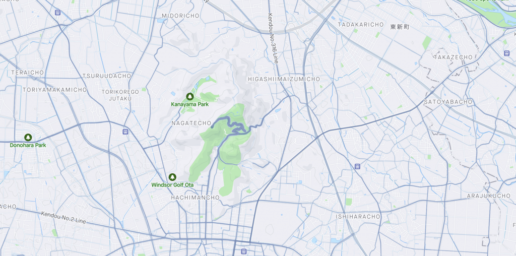
You can see in this screenshot above that the green mountain space with the windy road is a much brighter blue than the rest of the map, and indeed it is a very popular local climb.
This data is really really helpful, especially when out in extremely rural areas where one might even question, “does this road even exist?”.

In the above you can see the white road in the center of the screen has no blue hue to it indicating it has never been ridden and recorded on Strava to date. Now, this does not mean it is not a real road, but it does mean it is far less likely to be paved or even passable (especially in rural mountainous Japan).
The Difference Between Popular and Ideal
Just because a road is popular does not mean it is an ideal road to ride on. This is especially true in dense urban areas in Japan where many commuters record their daily commutes on Strava thus “muddying” the heatmap data with huge amounts of rides on less than ideal roads for cycling.
Imagine if each weekday a rider rode 10km to and from work on crappy busy roads because it was the most direct way. Then, on the weekend they did a single 50km ride in a nice location nearby. This rider logged 100km on a single stretch and 50km on a big loop. That will make the heatmap bright on their commute route and barely visible on the nice roads!
This is a key to understanding cycling heatmap data!
We will pickup on exactly how to discern this in the later section on Google Maps & Street View, but for now just focus on the idea that the heatmap can give you the following points of data.
- If a road exists.
- If a road has been ridden before.
- How popular the road is in relation to others in its vicinity.

2. National Roads & Prefectural Roads 国道と県道
In Japan the country is divided into 47 Prefectures. From here each prefecture is divided into cities, towns, and villages. When it comes to roads in Japan the two biggest types (besides highways where bikes are not permitted) are National Roads 国道 and Prefectural Roads 県道.
National Roads
A National Road is one that carries the same name/number across the whole nation. Fun fact, the National Road No 1 is the famous Tokaido 東海道 between Tokyo & Kyoto/Osaka. Another fun fact, this route is an absolute nightmare to navigate on a bike thanks to all the traffic. It provides a perfect example of how bad these National Roads often are.
In general National Roads are very very heavily trafficked.
Of course there are some exceptions, but if possible you should pretty much just avoid any National Roads you can when route planning if you want to avoid constant traffic noise & lots of stoplights.
Notice I did not say if you want to avoid dangerous roads. Many National Roads have very wide bike friendly pedestrian/cycling paths alongside them. These are fantastic for riding on, but again with a constant hum of 80kph tractor trailers & trucks beside you, they are far from enjoyable roads to spend a long time riding on.
Prefectural Roads
Prefectural roads are a real grab bag. Some are the most quiet tranquil and best paved rural roads you have ever seen, while others are as busy as National Roads and often with even less cycling/pedestrian infrastructure.
It is with much more scrutiny you will need to assess a Prefectural Road’s viability for your route planning, but in general there are a few quick tricks you can use.
Signs of a good Prefectural Road
- The road is winding and goes over a mountain/hill that has a nearby “bypass tunnel”.
- The road has few stoplights on the map.
- The road is in a rural area that has few houses/businesses/etc alongside it.
- The road is in a dense forest area.
- The road has a National road nearby that will likely take all of the traffic.
- The road “leads to nowhere”.
Signs of a bad Prefectural Road
- The road has many stop lights on the map.
- The road has no shoulder in many spots and many cars on the satellite image.
- The road is the shortest road from one city/town to another.
- The road is the “only road” from one city/town to another.
- The road has many train stations along it.
An Example of National vs Prefectural vs Other Roads

I love this example here on the border of Gunma & Nagano Prefecture. Above you will see three roads with the number 18, the upper most is the “Old 18” and is very very twisty. The middle is the “New 18” and has nice wide switchbacks. And the lower is the “Highway 18” with hardly a turn in sight. All three climb up over 1000m from Gunma to Nagano but as you can see in very very different ways.
Now of course you can’t ride your bike on a highway in Japan, but if you see a pattern like this where many roads go to the same place you can pretty safely assume most drivers will want the least twisty route as that will allow higher speed limits.
Indeed, the highway speed limit is around 100kph on this stretch, the middle “New 18” speed limit is 50kph, and the upper “Old 18” is 30-40kph. So, one can easily understand that cars willing to pay the toll for the highway will opt for that, then those who just want to get from A to B will take the New 18 over the Old 18 as it will be around 2x as fast.
Therefore we can pretty safely assume the Old 18 is the better cycling road, and it is! Further, did you notice the little squiggle monster of a road numbered 92 coming off of the New 18 and nearby the highway on the map?
This is also a Prefectural Road, but importantly it is much smaller than even the Old 18 and thus receives a different color on Google Maps. We will talk more about colors on Google Maps in the section below.
So, to summarize, National Roads are best avoided. Prefectural Roads can be a grab bag.

3. Rindo Forest Roads 林道
I have an entire article on all of the amazing features of Cycling in Rindo Forest Roads, so I would highly recommend checking that out if you haven’t already. But in short Rindo 林道 quite literally means forest road, and is a term used to mean any road that travels deep into a forest.
These roads come in a very very wide variety of qualities from beautifully smooth pavement, to rough pavement to gravel to just plain dirt. In the above article I focus on the Rindo roads around us in Kita Kanto Region which are by in large very nicely paved. But, many regions such as Hokkaido have mostly gravel or rugged pavement/cement Rindo.
In short, Rindo Forest Roads are often some of the quietest and most scenic roads in all of Japan. Many guests have said they feel more like they are mountain biking in terms of scenery and tranquility thanks to the often hours of time without car noise or traffic.
How to Identify a Rindo Forest Road?
This is really tricky to do right all the time, but there are a few tricks that can get you most of the way there. The biggest thing to confirm is that the road is paved (if that is what you are looking for) and the best way to do this is to see if it has a FULL Google Street View available. If so, you can feel fairly confident it is not only paved (and can confirm on Street View), but also that it is passable regardless of if it is on the Strava Heatmaps.

It is pretty easy to give this a quick check and we will go over the full use of Google Maps in the later section. So in short, if it ain’t blue, not sure you can do.
Cycling Paths vs Cycling Routes (Rivers & Lakes)
The less mountainous cousin of the Rindo Forest Road is the Cycling River Paths. Again, I have a great full in-depth article as well as map of the many amazing cycling river paths in the Kanto (Greater Tokyo) Region too to check out!
In fact, did you know the longest car free cycling path in Japan is in our backyard and stretches over 200km from the ocean to an Onsen hot spring town?!
If you are a fan of long cruisy flat miles Japan’s cycling paths are a fantastic way to see the countryside.
Differences Between a Cycling Path / Cycling Road and a Cycling Route
Many places in Japan have begun promoting Cycling Routes, none more famous at the moment than the Shimanami Kaido. These routes are often quite nice, and full of amenities and facilities, as well as a big blue arrow for keeping you on the route. BUT! There is a very very big difference between a cycling route and a cycling path in Japan, and most of the cycling routes include very little cycling path.
Take for example possibly the second most marketed cycling routes in Japan at the moment, Cycling around Lake Biwa aka the Biwa Ichi 琵琶一周. The route does a lot of things right such as the arrows to follow and around 1/2 of the route on a cycling path (albeit mostly next to a busy road). However it also spends nearly 1/4 of the route on what is unquestionably very busy and frankly in many spots dangerous roads.
You can see a full breakdown and my suggestions for an improved route to avoid all of this in my full article on Cycling Lake Biwa. But what I am trying to get at here is that many of these routes the government has begun laying down are not really designed around ideal cycling environment and more around the shortest distances from A to B or around X location.
5. Understanding Japanese Traffic Cycles
Japan is a very cyclical place, from the seasons to even the traffic. And just a little bit of knowledge of this can help one determine when it is best to start a day early or not show up at the peak of a holiday in a busy tourist town.
There are just a few simple tips you can master that will greatly improve your chances of minimal traffic and even lower costs for booking accomidations.
- Japanese Holidays are ALWAYS high traffic and more expensive. If you can, avoid them.
- Golden Week, Obon, Japanese New Year, and New Years are the big ones.
- 3 day weekends are common in Japan and make for heavy traffic from Fri night through Monday night.
- Rush hour exists even in small cities and towns. Typically 7-8:30am & 4-6pm.
If you keep those dates in mind, you will likely experience significantly less traffic.
As for time, often if you are in a congested/touristy area simply leaving and getting out of the dense/tourist area by 7am will prove to have virtually no traffic.

6. Google Maps & Street View
Ok so the final piece in the puzzle, and possible the most powerful and most time consuming part of the process.
You have checked the road on Strava Heatmaps, tried to find Rindo Forest Roads & River Paths, and you are now trying to understand if that prefectural road is going to be busy, or if that tiny road out in the middle of nowhere is even rideable on a road bike.
This is where Google Maps & Street View really save the day.
As stated before, you can drag that little yellow dude onto the map and if it lights up blue that means there is street view data OVER THE WHOLE ROAD! With this, you can (in theory) view the whole road and see what it would be like to ride it. Sweet!
However, realistically that is a huge waste of time, so how can I get that same level of confidence it is a good road to ride without looking at every single inch of the road? Well, this is where the art of it really comes into play.
First, you can start by simply dropping the little yellow guy in a few random places on the road and taking a look around. This often gets you a “rough image” of what the road is like.
Then, you might wonder how the traffic is on the road. This is where satellite data can give you a better idea. I say better, because remember these are a single photo on a single day, so it could be a lot worse or better than you see.
In general a road with many vehicles in the satellite image will be very crowded, one with just a few or none is likely to be very quiet.
How many is a lot and a few? Well again, this is the art of things. If the road is smaller and narrow just a few in a screen is a lot, but if it is wider and has two full lanes a few in a shot is not a ton.
Let’s look at an example.
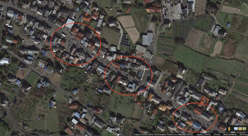
In this road you can see quite a few cars in both directions and no traffic lights nearby. One can pretty safely assume this road has pretty steady and heavy traffic.
Wrapping It All Up
You might be thinking, wait do you really check every road for all of these conditions when you plan a cycling route in Japan? And the short answer is, well kinda yeah. But I’m a bit weird and love knowing that I found the best possible roads to ride in each area I visit.
You only live once right, and many people might only visit Japan once or twice in their lifetime, so why wouldn’t you want to ride the best possible roads?
Now, as you do this more and more, like any skill or craft, you will get better at this process and it will not only take less time, but also you will develop ways to more quickly assess the quality of a route.
If you have any other tips for route building where you are or from your past experience in Japan feel free to share in the comments below.
Happy riding y’all!

More Rides & Reads
- Ashikaga, Tochigi (8)
- Bicycle Logistics in Japan (4)
- Bike Rental (3)
- Bikepacking Japan Routes (4)
- Cycling River Paths of Japan (5)
- Day Trips Rides from Tokyo (17)
- Famous Bike Routes in Japan (7)
- Food (4)
- Getting to Your Tour (4)
- Gifu Prefecture (1)
- Gunma Prefecture (20)
- Hakuba, Nagano (2)
- Hiking (4)
- Ibaraki Prefecture (1)
- Ikaho Onsen Town (4)
- Ise City, Mie (1)
- Ishikawa Prefecture (2)
- Japan Online (5)
- Japanese (2)
- Japanese Culture (7)
- Kagoshima Prefecture (1)
- Kanagawa Prefecture (1)
- Kanazawa City (2)
- Kansai Region (1)
- Kanto Area Rides (16)
- Kanto Region (20)
- Kii Peninsula (1)
- Kiryu City, Gunma (14)
- Kita Kanto Area Rides (18)
- Kita Kanto Region (25)
- Kumano Kodo (1)
- Kyoto (3)
- Kyushu (1)
- Lake Biwa (2)
- Maebashi City (1)
- Matsumoto City, Nagano (6)
- Mie Prefecture (1)
- Minami Alps National Park (2)
- Mount Fuji (4)
- Mount Haruna (4)
- Mountain Biking Japan (1)
- Nagano Prefecture (11)
- Nara Prefecture (1)
- Nikko National Park, Tochigi (9)
- Nikko, Tochigi (9)
- Noto Peninsula (2)
- Onsen Hot Springs (2)
- Ryokan Hotels (6)
- Saitama Prefecture (1)
- Self Guided Cycling Routes in Japan (5)
- Seto Naikai (Inland Sea) Region (3)
- Shibukawa, Gunma (1)
- Shiga Prefecture (1)
- Shimanami Kaido (4)
- Shizuoka Prefecture (5)
- Snow Season in Japan (Ski & Snowboard) (1)
- Takasaki City, Gunma (4)
- Tochigi Prefecture (14)
- Tokyo Area Rides (11)
- Toyama City (2)
- Toyama Prefecture (2)
- Travel in Japan (13)
- Uncategorized (8)
- Utsunomiya, Tochigi (1)
- Wakayama 800 (1)
- Wakayama Prefecture (1)
- Yamanashi Prefecture (5)
Good morning from Australia,
Thank you for your excellent and informative articles.
It is a dream of mine to come and cycle across Japan in the next few years.
I would enjoy more quiet country and coastal regions, with chances to say hello to local people.
Can you please help me with information on obtaining a cycle to use.
I see a few options.
I can pay a lot of money and transport my own bike and pannier across to Japan
I could perhaps hire a suitable bike and panniers??
Or is it feasible to go to a bike shop and purchase a reasonable quality bike in the city I land in and then enjoy my tour. Either selling or donating the cycle at the end of my journey.
I would appreciate any insights please
Regards
Murray
Hi Murray it’s a tough one to say as it matters how long you will be here. Less than 2 weeks probably rental. Greater than that maybe buy.
Hey Murray,
Im an amature bike rider here in Melbourne. Maybe 4 times a week.
Just did the Shiminami Kaido in October 2024
I flew JAL that was supported by Qantas
If you break the bike down to the correct dimensions, you can check the bike in as one of your two allowed checked in baggage.
The hotel I stayed at by the airport the first and last night held onto my stuff as I biked.
Not sure about buying a bike there, but I think it’s hard to sell or even donate a bike unless you have proof of purchase. As I understand, residents have to register the bike with proof of purchase.
Hi. I plan a trip to Japan for two months next autumn. I’d like to buy a used ebike in Sapporo and get rid of it two months later in Fukuoka. (selling it half price? I found somewhere that anyone can registrer a bike when you buy it). I just wondered how easy it is to ensure that the places I will stay overnight have the possibility to store my ebike and to recharge the battery. I’m not going to plan the whole trip in advance and will just make reservations a day or two in advance as I progress southward through the country. Cozycozy website seems Ok for finding places within my budget (less than 50€ / 8000Y a night) . I will mostly avoid big cities. Any ideas?
Hi from Canada. We enjoyed two days cycling on the Shimanami Kaido on our first trip to Japan this June. So, much so, that we would like to return for a group tour or self guided this winter (Dec, Jan.) Do you have any trips or suggested itinerates in the Okinawa prefecture that are warmer these months?
Hi Mike, Thank you. We’re glad to hear you enjoyed riding the Shimanami Kaido. Our team will reach out to you directly by email to share options for winter cycling in Japan!