Cycling the River Paths of Japan
Table Of Contents
Introduction
Japan is quietly a cycling infrastructure mecca of the world. Many know of the world class bullet trains and extensive train networks in the dense metro areas. But if you only visit the major cities and tourist hubs such as Tokyo and Kyoto you will miss the true extent of Japan’s cycling paths.
Japan is home to some of the best car free riding in the world!
Most of Japan’s amazing riding comes down to two unique types of roads they have: River Cycling Paths, and Forest Roads called Rindo 林道. About half way down this post is a map of all of the River Cycling Paths/Roads in the Kanto Region (Greater Tokyo).

Why Are There So Many Cycling Paths on the Rivers in Japan?
Japan is an island nation that is made primarily from volcanic activity. This is both a blessing and curse as the islands are mostly formed of steep jagged mountains. In fact, over 80% of Japan’s total land is uninhabitable wilderness!
With these steep mountains, wet summer climate of Typhoons, and heavy snow melt in spring, much of Japan’s terrain is shaped by water. From this, the people of Japan have a rich history of an intimate relationship with the water that forms their island from both the sea below and the skies above.
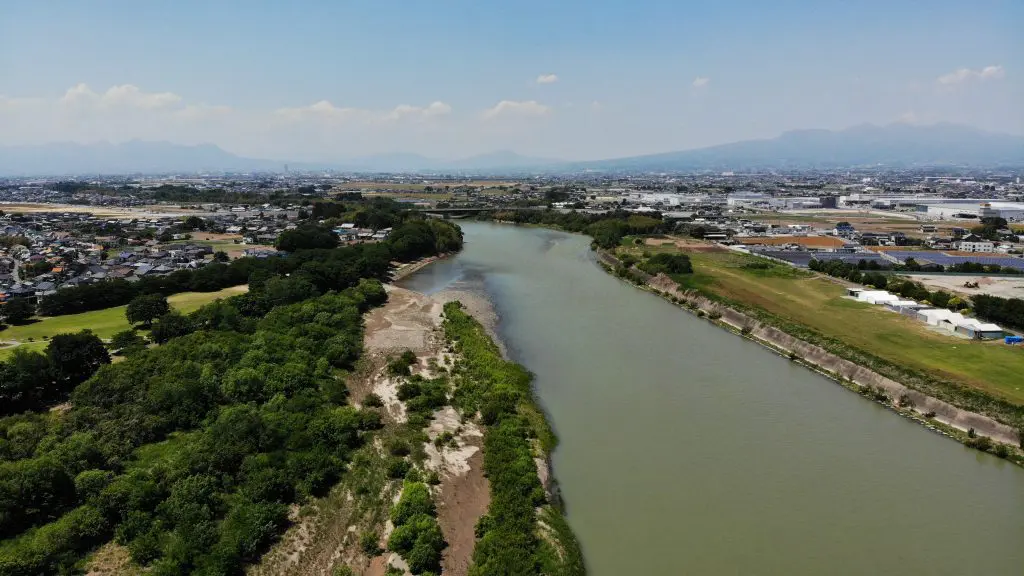
Because of this, there is a lot of flood control to be done in Japan. In fact, most all major rivers have tall dykes or levees to protect those that live nearby.

What is a River Cycling Path Like in Japan?
On most of the major rivers the levee has a concrete pedestrian only path. This means it’s just cyclists and pedestrians allowed. Awesome!
What more, being typically raise 5-10 meters (15-30ft) above the riverbed this means you get some of the best views in town from them. Double awesome!

Where can I go on These River Paths?
The possibilities are really endless across the thousands of kilometers of cycling paths in Japan. Our favorite routes though incorporate transiting sizable distances along the larger rivers of the Kanto and Kita-Kanto Region.
One example is our Tokyo to Gunma | 3 Rivers Ride that spans from the high-rises of central Tokyo out to through the rice fields of central Kanto and eventually to the high mountains of the Kiryu Alps.

Notable River Cycling Paths in Japan
Kanto Region
Below is a map of the Kanto Region and the many cycling roads along the rivers and canals in the region.
Controlling the map
– If you click the button the the top left you will open a menu allowing you to turn on and off the major and minor paths as well as search based on name.
– If you click the button in the the top right you can open a new window with the map in full screen for easier viewing.
– You can zoom in and out as well as click on the the paths to highlight them and see their names.
Tone River Cycling Path
AKA: Tonegawa Cycling Road | 利根川サイクリングロード
The longest contiguous cycling path in all of Japan the Tonegawa Cycling Road is a mind-blowing 268km long! Starting from the center of Gunma Prefecture at Shibukawa City 渋川市 (just below Ikaho Onsen Town) heading all the way to the ocean in Chiba Prefecture at the small port town of Choshi 銚子市.
This is the main artery of Tokyo out into the greater Kanto and Kita-Kanto Regions.
When heading east on the Tone River Path you can also easily connect to the cycling route around the second largest lake in Japan, Kasumigaura in Ibaraki Prefecture!
Read Our Guide to Cycling around Kasumigaura
Tama River Cycling Path
AKA: Tamagawa Cycling Road | 多摩川サイクリングロード
The most popular cycling river path for those living in Tokyo, the Tamagawa Cycling Road stretches from Kawasaki harbor out to the mountains of Chichibu-Tama-Kai National Park.
Though a bit too far for morning rides to reach Chichibu, avid cyclist in Tokyo regularly choose to reside on this side of Tokyo for ease of access to this river for weekend adventures out to the mountains.
Ara River Cycling Path
AKA: Arakawa Cycling Road | 荒川サイクリングロード
The Arakawa is probably the second most popular amongst Tokyo dwellers for their weekday and shorter weekend rides. Also leading out east towards the mountains of Chichibu, the Arakawa provides a flatter route into the heart of the Chichibu mountains.
Edo River Cycling Path
AKA: Edogawa Cycling Road | 江戸川サイクリングロード
The Edogawa is the main route north out of Tokyo for cyclists. Medium in length, it connects to the Tonegawa Cycling Road at it’s northern end. From here all of Kita-Kanto is accessible, as well as routes east to the ocean or Kasumigaura via the Tone River.
Watarase River Cycling Path
AKA: Watarasegawa Cycling Road | 渡良瀬川サイクリングロード
The Watarase is a tributary of the Tone, and with that splits from the Tone around Tatebayashi in Gunma Prefecture. At around 50km in length it passes through Ashikaga City before the cycling road ends in the historic silk town of Kiryu, Gunma. From here the you can continue up the Watarase River to its origin situated between the Kiryu Alps & Mount Akagi.
Other Notable Cycling Paths
Shimanami Kaido
Quite possibly the most famous of Japan’s cycling courses the Shimanami Kaido is a stretch of islands linked by bridges that spans the Seto Naikai, or inland sea of southern Japan.
Lake Biwa Ichi Cycling Route
AKA: Biwaichi ビワイチ
The largest lake in Japan, Lake Biwa 琵琶湖 is home to a cycling route that traces the lakeside for around 200km. Although it is the largest lake, this loop is significantly more populated than the Kasumigaura loop.

Kasumigaura Cycling Route
The second largest lake in Japan, the Kasumigaura Ring Road is just north of Tokyo and the far less densely populated of the two major lake cycling routes in Japan.
More Rides & Reads
- Ashikaga, Tochigi (8)
- Bicycle Logistics in Japan (4)
- Bike Rental (3)
- Bikepacking Japan Routes (4)
- Cycling River Paths of Japan (5)
- Day Trips Rides from Tokyo (17)
- Famous Bike Routes in Japan (7)
- Food (4)
- Getting to Your Tour (4)
- Gifu Prefecture (1)
- Gunma Prefecture (20)
- Hakuba, Nagano (2)
- Hiking (4)
- Ibaraki Prefecture (1)
- Ikaho Onsen Town (4)
- Ise City, Mie (1)
- Ishikawa Prefecture (2)
- Japan Online (5)
- Japanese (2)
- Japanese Culture (7)
- Kagoshima Prefecture (1)
- Kanagawa Prefecture (1)
- Kanazawa City (2)
- Kansai Region (1)
- Kanto Area Rides (16)
- Kanto Region (20)
- Kii Peninsula (1)
- Kiryu City, Gunma (14)
- Kita Kanto Area Rides (18)
- Kita Kanto Region (25)
- Kumano Kodo (1)
- Kyoto (3)
- Kyushu (1)
- Lake Biwa (2)
- Maebashi City (1)
- Matsumoto City, Nagano (6)
- Mie Prefecture (1)
- Minami Alps National Park (2)
- Mount Fuji (4)
- Mount Haruna (4)
- Mountain Biking Japan (1)
- Nagano Prefecture (11)
- Nara Prefecture (1)
- Nikko National Park, Tochigi (9)
- Nikko, Tochigi (9)
- Noto Peninsula (2)
- Onsen Hot Springs (2)
- Ryokan Hotels (6)
- Saitama Prefecture (1)
- Self Guided Cycling Routes in Japan (5)
- Seto Naikai (Inland Sea) Region (3)
- Shibukawa, Gunma (1)
- Shiga Prefecture (1)
- Shimanami Kaido (4)
- Shizuoka Prefecture (5)
- Snow Season in Japan (Ski & Snowboard) (1)
- Takasaki City, Gunma (4)
- Tochigi Prefecture (14)
- Tokyo Area Rides (11)
- Toyama City (2)
- Toyama Prefecture (2)
- Travel in Japan (13)
- Uncategorized (8)
- Utsunomiya, Tochigi (1)
- Wakayama 800 (1)
- Wakayama Prefecture (1)
- Yamanashi Prefecture (5)