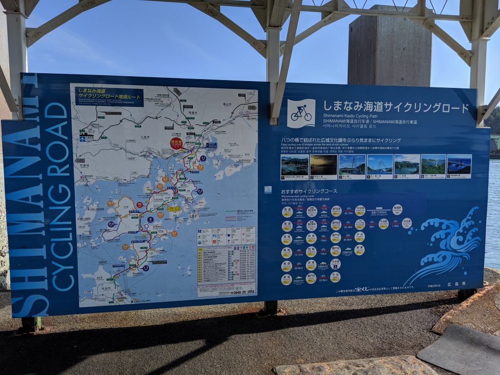
Shimanami Kaido Map | Cycling Route
What is the Shimanami Kaido?
Quite possibly the most famous of Japan’s cycling courses, the Shimanami Kaido (Map) is a stretch of islands linked by bridges that spans the Seto Naikai, or inland sea of southern Japan.
Situated between the main island of Honshu and the southern island of Shikoku, the Shimanami Kaido boasts views of turquoise seas, small fishing towns, endless islands of citrus, and the longest suspension bridge in Japan.
And the best part? you can ride it all by bike!

Download Full Shimanami Kaido Cycling Map
Shimanami Kaido Map – Japanese 日本語

Guide to Cycling the Shimanami Kaido
Other Places to Ride in Japan
Japanese Tourism Website for the Shimanami Kaido
More Rides & Reads
- Ashikaga, Tochigi (8)
- Bicycle Logistics in Japan (4)
- Bike Rental (3)
- Bikepacking Japan Routes (4)
- Cycling River Paths of Japan (5)
- Day Trips Rides from Tokyo (17)
- Famous Bike Routes in Japan (7)
- Food (4)
- Getting to Your Tour (4)
- Gifu Prefecture (1)
- Gunma Prefecture (20)
- Hakuba, Nagano (2)
- Hiking (4)
- Ibaraki Prefecture (1)
- Ikaho Onsen Town (4)
- Ise City, Mie (1)
- Ishikawa Prefecture (2)
- Japan Online (5)
- Japanese (2)
- Japanese Culture (7)
- Kagoshima Prefecture (1)
- Kanagawa Prefecture (1)
- Kanazawa City (2)
- Kansai Region (1)
- Kanto Area Rides (16)
- Kanto Region (20)
- Kii Peninsula (1)
- Kiryu City, Gunma (14)
- Kita Kanto Area Rides (18)
- Kita Kanto Region (25)
- Kumano Kodo (1)
- Kyoto (3)
- Kyushu (1)
- Lake Biwa (2)
- Maebashi City (1)
- Matsumoto City, Nagano (6)
- Mie Prefecture (1)
- Minami Alps National Park (2)
- Mount Fuji (4)
- Mount Haruna (4)
- Mountain Biking Japan (1)
- Nagano Prefecture (11)
- Nara Prefecture (1)
- Nikko National Park, Tochigi (9)
- Nikko, Tochigi (9)
- Noto Peninsula (2)
- Onsen Hot Springs (2)
- Ryokan Hotels (6)
- Saitama Prefecture (1)
- Self Guided Cycling Routes in Japan (5)
- Seto Naikai (Inland Sea) Region (3)
- Shibukawa, Gunma (1)
- Shiga Prefecture (1)
- Shimanami Kaido (4)
- Shizuoka Prefecture (5)
- Snow Season in Japan (Ski & Snowboard) (1)
- Takasaki City, Gunma (4)
- Tochigi Prefecture (14)
- Tokyo Area Rides (11)
- Toyama City (2)
- Toyama Prefecture (2)
- Travel in Japan (13)
- Uncategorized (8)
- Utsunomiya, Tochigi (1)
- Wakayama 800 (1)
- Wakayama Prefecture (1)
- Yamanashi Prefecture (5)